← Home
💧

Our Hydrological Heritage

Water Canton of Costa Rica

The Poás canton is guardian of one of Costa Rica's most valuable resources: water. Its forests, rivers and aquifers supply millions of people.

💧 Poás Water Observatory

A comprehensive look at the canton's water resource: from where the water is born to how we protect it. Explore the key topics of Poás's water heritage.

💦

Micro-watersheds

Drainage units born in the massif that feed the canton's rivers.

🏞️

Rivers

Courses such as the Poás and Prendas that run through and give life to the canton.

🌊

Streams

Small channels that drain the slopes and recharge the rivers.

⛲

Springs

Sources that flow from the aquifer and supply the ASADAS water boards.

🕳️

Aquifers

The Poás, Colima and Barva underground reserves that supply the metro area.

🌧️

Recharge zones

Areas where rainwater infiltrates and recharges the aquifers.

🧪

Water quality

Monitoring the potability and health of the water bodies.

🛡️

Protection projects

Initiatives to conserve springs, channels and recharge forest.

🌳

Reforestation

Planting trees in recharge zones to secure water for the future.

☣️

Pollution

Threats from agrochemicals, wastewater and solid waste.

📣

Environmental reports

Report impacts to the canton's water resource.

Report →
📊

Historical data

Records and evolution of the water resource over time.

💡 Poás Water by the Numbers

3
Main aquifers recharged
+2M
People who depend on water from the massif
+15
Active ASADAs in the canton
2,704 m
Altitude of Poás volcano (recharge zone)
+5,000 mm
Annual rainfall on the massif
100%
Drinking water coverage in the canton

🌊 Aquifers of Poás

The Poás massif recharges three aquifer systems that supply drinking water to the Greater Metropolitan Area.

💧
Poás Aquifer
High Zone

Aquifer located in the upper part of the canton, in the area closest to Poás Volcano. It is the main source of water for the ASADAs, the Municipality of Poás and the city of Alajuela, through wells and springs. It is recharged through porous volcanic soils and the cloud forest, but shows high vulnerability to contamination from agricultural and livestock activities in the sub-basin.

🏔️ High zone 🌧️ High recharge
🌊
Colima Aquifer
Greater Metropolitan Area

One of the most important aquifers in Costa Rica. It receives recharge from the Poás massif and supplies a large part of the Central Valley. It is a key source for SENARA and AyA for the provinces of Heredia and Alajuela.

🏙️ Central Valley 💦 High output
🫧
Barva Aquifer
Northern GMA Zone

Located beneath the slopes of the Barva-Poás massif, this unconfined aquifer is recharged by rain filtering through porous volcanic soils. It supplies communities in the northern Greater Metropolitan Area and part of Heredia.

🌿 Volcanic soils 🏘️ High demand

🏞️ Rivers & Watersheds

From the volcano spring rivers that irrigate the canton and supply downstream communities.

🌊
Poás River
Originates on the volcano's slopes. It crosses the canton and its banks sustain local agriculture and biodiversity.
🔷
Poasito River
An important tributary rising in the western zone of Poás Volcano National Park. It forms part of the Poás River sub-watershed and the Grande de Tárcoles River basin.
💙
Sarapiquí River (headwaters)
Its headwaters originate in the volcanic massif. It flows toward the Caribbean slope with a large discharge.
🌿
Toro River
A tributary descending from Poás. Used in hydroelectric projects and a source of drinking water.
🔵
Streams & springs
Dozens of smaller streams and freshwater springs directly supply the canton's ASADAs.
🏔️
Botos Lagoon
An inactive volcanic crater turned into a lagoon. A unique ecosystem within Poás Volcano National Park.
🌫️
Cloud Forest
The forest mist at 2,000–2,700 m captures atmospheric moisture and continuously recharges the aquifers.

🚰 Water Management Associations (ASADAs)

The Communal Aqueduct and Sewerage Management Associations are the cornerstone of water access in Poás.

The ASADAs of the upper Poás River basin manage communal aqueducts that deliver drinking water directly from natural sources to homes. They are non-profit organisations run by the communities themselves, under the supervision of AyA (Costa Rican Institute of Aqueducts and Sewers). Their work is essential for preserving both water quality and the health of springs and recharge zones.

ASADA Santa Rosa
Canton of Poás
ASADA San Juan Norte
District San Juan
ASADA Calle Liles
District San Juan
ASADA Calle San José - Calle Rodríguez
Canton of Poás
ASADA Mastate
Canton of Poás
ASADA Poasito
Canton of Poás
ASADA Fraijanes
District Fraijanes
ASADA Calle El Sitio
District Fraijanes
ASADA San Miguel
Canton of Poás
ASADA Cañón
Canton of Poás
ASADA Los Ángeles
Canton of Poás
ASADA San Isidro
Canton of Poás

📋 Hydrological Resources of the Poás Canton

Technical and contextual information about the canton's water system.

🗺️

Location and general context

The canton is located within the Grande de Tárcoles River sub-basin, which drains the Central Valley's waters to its outlet on the Pacific Ocean. It has a territorial area of 73.84 km², spread across a strip approximately 15 km long by 5 km wide, with elevations ranging from 600 m a.s.l. in Rincón de Carrillos to 2,838 m a.s.l. in Poás Volcano National Park.

🌊

Main rivers and boundaries

The courses of the Poasito and Poás rivers define the eastern boundary with the canton of Alajuela, while the Achiote, Tacares and Prendas rivers define the western boundary with the canton of Grecia.

With Grecia, Poás shares the sub-basins of the Tacares and Prendas rivers — an area of great abundance of groundwater, springs and water intakes, including the Los Chorros spring, located in the protected area of the same name.

🏔️

Poás River micro-watershed

Located between Barva volcano and Poás volcano, down to the confluence with the Grande River near Alajuela. It has high potential for the formation of high-quality aquifers.

Over the past 14 years, water production in the micro-watershed has increased by 1.6%, specifically in runoff and hydrological gain.

💧

Poás Aquifer and human consumption

Water for human consumption comes from wells and springs, primarily from the Poás aquifer. Despite the intrinsic vulnerability of this aquifer to contamination, livestock and agricultural activities have been developed across a large part of the sub-basin's territory.

Population centres primarily use septic tanks as sanitation systems, which represents a contamination risk for both groundwater and surface water.

🌾

Socio-environmental pressures

The micro-watershed has a socioeconomic structure based on agro-productive activities: cattle ranching, poultry farms, sugarcane, coffee and non-traditional crops such as flowers, strawberries and vegetables, which exert pressure on water resources.

Six socio-environmental pressures with a negative impact on water were identified, originating from both households and productive activities. Despite this, water quality parameters showed majority compliance with established quality criteria.

⚡

Natural risks to water

Flash floods and landslides are associated with the presence of deeply incised river valleys with steep slopes in elongated micro-watersheds over recent volcanic deposits.

Identified risks range from volcanic eruptions, tectonic faults and landslides to human-induced threats that have caused degradation and contamination of soils and surface and groundwater.
⚠️ Threats & Challenges

Understanding the risks is the first step to protecting the canton's water.

🌡️ Climate change

Changes in rainfall patterns affect aquifer recharge and reduce river and stream flows during the dry season.

🏗️ Unplanned urbanisation

Soil sealing from construction reduces water infiltration and contaminates aquifers with wastewater.

🌾 Agrochemicals

Excessive use of fertilisers and pesticides in highland farming areas can contaminate springs and underground aquifers.

🌋 Volcanic activity

Eruptions from Poás can temporarily affect water quality through acidification and emission of sulphurous gases.

🪵 Deforestation

Loss of forest cover in recharge zones reduces the soil's capacity to capture and filter rainwater.

🚯 River pollution

Improper disposal of solid waste and sewage in river basins degrades the quality of water resources.

🏙️ Urban Pressure

Anthropogenic impacts from urban development, including overexploitation for water supply and contamination from discharges.

🗺️ Hydrological Cartography

Technical maps on the watershed, recharge zones and biodiversity of the Poás canton.

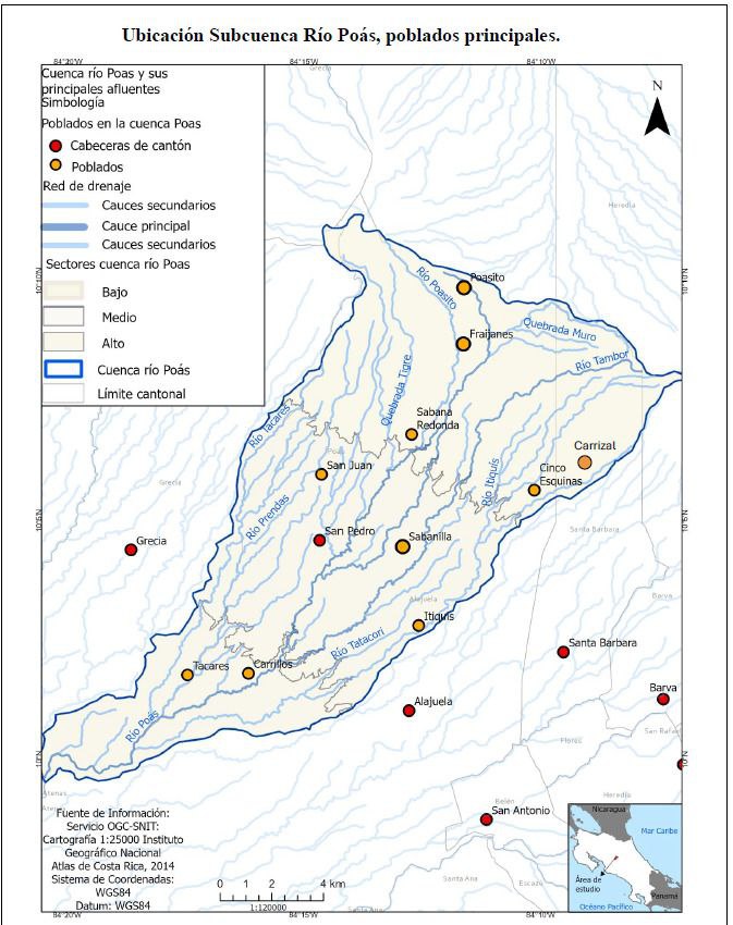
Río Poás Sub-watershed location — main towns
🏞️ Watershed
Río Poás Sub-watershed — Main Towns

Shows the delimitation of the Río Poás sub-watershed, its main tributaries (Río Poasito, Quebrada Tigre, Río Tacares, Río Tatacón) and the towns within it: Poasito, Fraijanes, San Juan, San Pedro and Carrillos. Divides the watershed into upper, middle and lower sectors. Source: OGC-SNIT / IGN, scale 1:120,000.

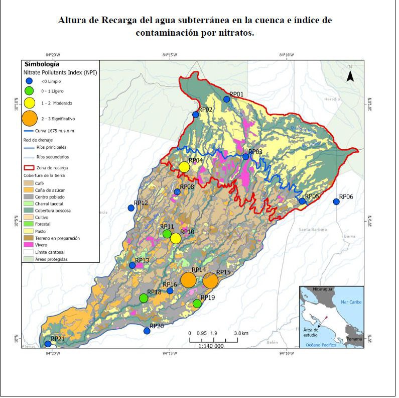
Groundwater recharge height and nitrate contamination index
💧 Aquifers & Quality
Groundwater Recharge & Nitrate Contamination Index (NPI)

Identifies groundwater recharge zones above the 1,675 m.a.s.l. contour and the level of nitrate contamination at 21 sampling points (RP01–RP21), classified from clean to significant. Reflects the pressure of agricultural and livestock activities on the aquifers. Scale 1:140,000.

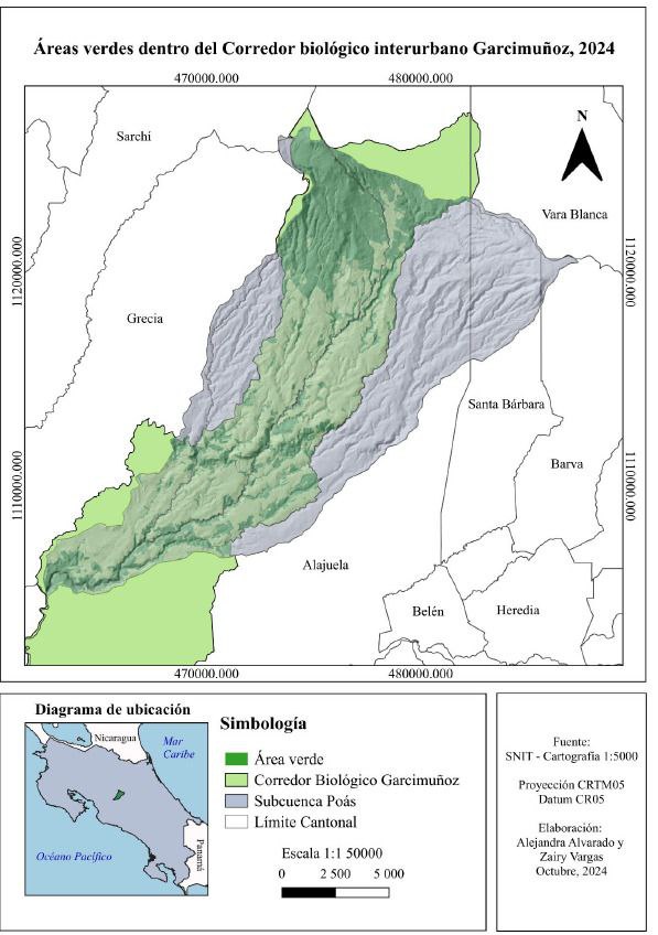
Green areas within the Garcimuñoz Interurban Biological Corridor, 2024
🌿 Biodiversity
Garcimuñoz Interurban Biological Corridor (2024)

Delimits the green areas and forest cover within the Garcimuñoz Interurban Biological Corridor, which crosses the Poás sub-watershed. This corridor plays a key role in ecological connectivity and protection of hydrological recharge zones. Source: SNIT, cartography 1:5,000. Prepared by Alejandra Alvarado and Zairy Vargas, October 2024.

💙 Let's protect water together

The hydrological heritage of Poás is everyone's responsibility. Learn more about the canton and its natural resources.

← Back to Home 📢 Report a problem 🗺️ Land Use Plan