Canton of Poás · Alajuela · Costa Rica

Poás

History, Nature & Culture

A territory where colonial history, extraordinary biodiversity and a cultural identity deeply rooted in volcanic soil converge in perfect harmony.

🗓️ Founded October 15, 1901 · Province of Alajuela, Costa Rica
▼ Scroll to explore

"Poás is where the earth breathes, water springs from the stones, and life flourishes in every corner."

The canton of Poás is one of the most fascinating corners of Costa Rica. Nestled on the slopes of the imposing Central Volcanic Mountain Range, this territory combines in perfect harmony a rich colonial history, extraordinary biodiversity and a cultural identity deeply rooted in the land.

Officially known as the "Water Canton of Costa Rica", Poás possesses an enormous number of natural springs that emerge from the slopes of the volcano that gives it its name, supplying a large portion of the Central Valley.

1901
Year founded
5
Districts: San Pedro, San Juan, San Rafael, Carrillos and Sabana Redonda
73.84
km² territory
2,708
masl Poás Volcano
220
Bird species recorded in the park
Chapter 1

History & Culture

Pre-Hispanic Origins

The history of the territory we know today as the canton of Poás stretches back to times before the Spanish conquest. Archaeological investigations at the sites of Río Prendas, Poás, Quebrada Caña, Solís and San Pedro have identified two settlement patterns:

  • 300 – 800 AD: Human presence with dispersed villages across the present-day territory.
  • 800 – 1562 AD: More developed occupation, linked to Chibcha-speaking groups known as the botos.

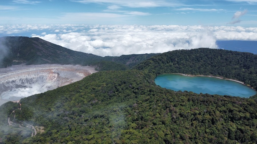
The botos inhabited the slopes of the volcano and their name would also be given to the famous Laguna Botos, an extinct crater that today forms part of the National Park.

Craters of Poás Volcano

Colonial Founding and the Name "Poás"

The first document mentioning the hamlet of Poás dates from 1782, when the parish priest Juan Manuel López del Corral referred to five hamlets in the region: Los Targuases, La Alajuela, Las Ciruelas, Río Grande and Pías.

The name "Poás" has several interpretations. Some historians link it to the Latinized form of "pías," referring to thorny plants. Others relate it to the indigenous toponym west of the Poás River.

The first colonizers included families such as the Herrera, Murillo, Chaves and Zamora.

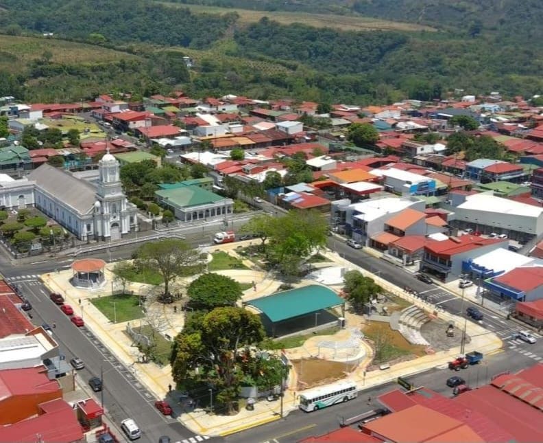
Town center of San Pedro de Poás

Timeline

300 – 800 AD
First villages
Human presence with dispersed villages across the territory, according to archaeological investigations.
1663
First recorded mention of the name Poás
Appears recorded for the first time referring to the "Potreros del Pías," between Grecia and Alajuela.
1782
First official document
Parish priest Juan Manuel López del Corral mentions the hamlet of Poás in a letter to the Bishop of Costa Rica.
1901
Creation of the Canton
On October 15, 1901, the canton of Poás is officially established during the administration of President Rafael Iglesias Castro.
1971
Poás Volcano National Park
On January 25, the national park is established, championed by biologist Mario Boza.
2017 – 2018
Eruption and park reopening
An eruption in April 2017 causes temporary closure. The park partially reopens in August 2018 with improved safety measures.
🎃
Oral Tradition · San Pedro District

San Pedro de la Calabaza

There are two versions of how the name la Calabaza — the gourd — came to this San Pedro de Poás in times long past.

One says it all began because a cranky old man from here was sorely troubled by the boys' rowdiness at night. Since they would not let him sleep, the good man first tried to end the nuisance the pleasant way, that is, with sound advice; but when that failed he adopted another method, that of scolding and threats, and things only got worse.

So he decided a change of tactics was in order. Since gourd vines grew in abundance here, he took one, hollowed it out carefully and cut into it with a knife two holes for the eyes and another that mimicked the mouth of a great skull. At night he took to wandering with the scarecrow, a candle set inside it, around the places where the troublesome boys were in the habit of carousing, and so he put an end to that torment, for the lads fled in terror at the sight of the apparition.

The other tells us that, since gourd vines grew thick where the park now stands, people gave the town the name San Pedro de la Calabaza, which can still be heard around here now and then. True or not, so the legends say.

📖 Source: Generalidades del Cantón de Poás.
"Poás is one of the oldest towns in Costa Rica, with a truly colonial origin that its inhabitants carry with pride." — Historian Percy Rodríguez Argüello
The Districts

History of the Districts

The Poás canton is made up of five districts, each with its own story of founding, founding families and transformation over time.

1°

San Pedro (Central District)

Origins and first settlers: tradition holds that formal immigration began around 1806 and 1835 with ten married families (such as the Murillo, Herrera, Chaves, Rodríguez and Zamora) coming from Heredia, drawn by the fertile land for farming and cattle raising, as well as the abundance of firewood. The town's founding as San Pedro de la Calabaza is traditionally placed around 1835.
Political consolidation and name: in 1852 it was a humble village with only 16 wooden houses and 8 thatched huts along a single street. It became a town and head of the new canton in 1901 and received the title of City by Decree No. 3200 of September 21, 1963.
Indigenous settlements: neighborhoods such as Chilamate and El Común (La Hilda) held Indigenous settlements of the Botos tribe.
2°

San Juan

First traces and immigration: it arose alongside the settlement of the highlands between the center of San Pedro and the Poás volcano massif. It was inhabited mostly by families of farming tradition with deep religious roots (chiefly the Ugalde and Herrera families).
Historical development: for decades it was the obligatory pass on the traditional ascent to the volcano. In its San Juan Norte neighborhood (Cabuyal), in the mid-20th century (1950s) farming and cabuya-spinning projects were tested, giving the area its popular name. In the canton's transport history, it was San Juan native don José Ugalde García who, in the 1920s, brought the first automobile to all of Poás.
3°

San Rafael

Old name and population: formerly known as Churruca (today the Churuca neighborhood), the district formed with the arrival and consolidation of families such as the Chaves, Gómez, Solís, Quesada, Rojas and Campos, among others.
Agricultural origins and a coffee milestone: it was in this district that, at the end of the 19th century, don Santiago Rodríguez Campos planted the first 40 coffee plants brought from Alajuelita, precisely where the San Rafael sports field stands today.
Territorial tensions and development: in 1930 a group of residents made a failed attempt to break away from the Poás canton to join Grecia. Nonetheless, the district kept growing until it became the second most densely populated in the canton during the 20th century.
4°

Carrillos

Origin of the name: it relates to the history of the old roads and the public opening of routes between Alajuela, Grecia and San Pedro from the late 19th century.
Population and growth: historically the smallest district in land area, but the most densely populated. Formed by historic hamlets such as Bajo de Carrillos (head town), Alto de Carrillos (Platanillo), Ingenio Pinto and Hacienda Sonora.
Economic evolution: it went through a strong productive transition: from a diversified farming zone (pineapple, cassava, rice and large amounts of sugarcane industrialized in mills such as Ingenio Pinto/Costa Rica) to the predominance of coffee plantations and cement and starch industries in the second half of the 20th century.
5°

Sabana Redonda

Old names and belonging: in earlier times it was known as Tejarcillos or "Pilas". Before the Poás canton was created in 1901, the Sabana Redonda area belonged administratively to the Sabanilla de Alajuela district.
Territorial disputes: during the canton's emancipation process between 1890 and 1901 there was a territorial conflict between the residents of San Pedro and Sabanilla, as both sought to annex the lands of Sabana Redonda. It was finally integrated into Poás through the canton's founding decree.
Evolution of the landscape: it went from a steep highland zone of scrubland, timber and charcoal production to a prosperous area of fine-cattle dairies, vegetable, flower and strawberry farming, and a tourism gateway to the Poás Volcano National Park.
Chapter 2

The Poás Volcano

Geological Description

Poás Volcano is an active stratovolcano reaching 2,708 meters above sea level, located at the heart of the Central Volcanic Mountain Range. Its main crater measures approximately 1.6 km in diameter and 300 meters in depth, making it one of the largest active craters in the world.

The volcanic massif is composed of three distinct craters. The main one houses the famous Laguna Caliente, whose sulfur-hypersaturated waters give it a turquoise or grayish hue. The second, extinct crater contains the beautiful Laguna Botos, a cold-water lake surrounded by cloud forest.

Its origin is due to the subduction of the Cocos Plate beneath the Caribbean Plate, a process that began approximately one million years ago.

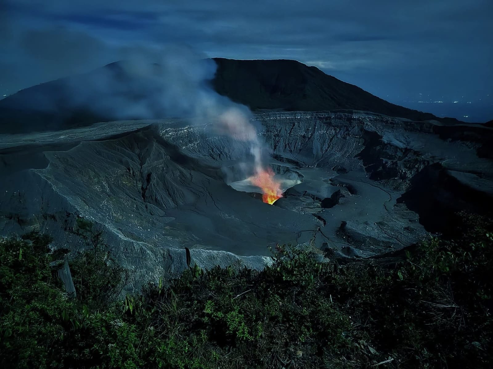
Poás Volcano crater at night

Eruption History

Poás Volcano has a documented eruption history dating back to the 19th century. The most notable eruption occurred in 1910, when an ash column rose to 8,000 meters in height, considered one of the largest phreatic eruptions of the 20th century in Central America.

Geothermal activity is permanent: fumaroles emitting sulfur dioxide and water vapor can be observed from the crater. On occasion, pressure geysers burst from the lake reaching up to 250 meters in height.

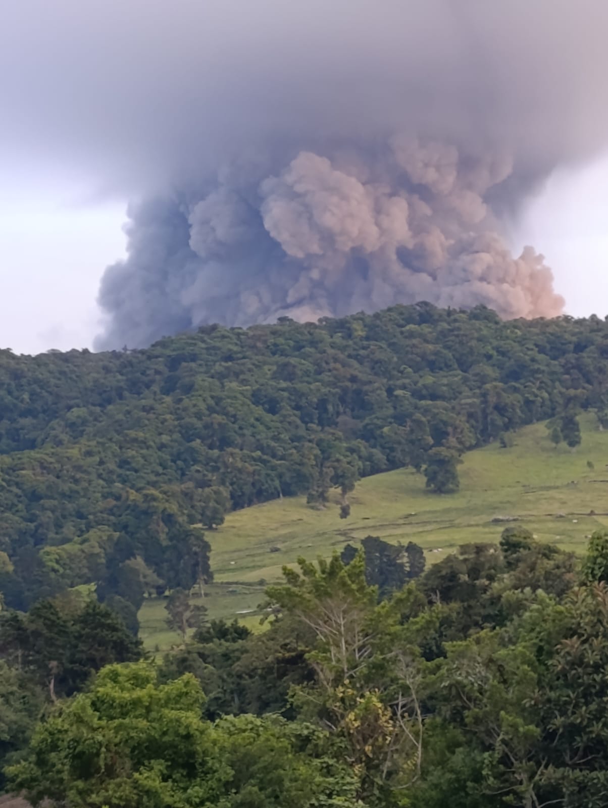
In April 2017, an eruption of gases, ash and rocks caused significant damage. Following safety improvements, the park partially reopened in August 2018.

Eruption of Poás Volcano

Eruptive Chronology

Nearly two centuries of documented activity. Poás is one of the most closely studied volcanoes in Costa Rica, and its characteristic behaviour is phreatic: water from the Laguna Caliente becomes superheated and is thrown out violently along with gases, mud and rock fragments.

19th century
First written records
Activity at Poás appears in written records from the early decades of the 19th century. In 1834, ashfall is reported over the towns of the Central Valley.
1910
The great phreatic eruption
On January 25, a column of ash and steam rises some 8,000 metres. It is the largest eruption recorded at the volcano and one of the largest phreatic eruptions of the 20th century in Central America.
1952 – 1954
A prolonged eruptive cycle
A period of sustained activity, with Strombolian episodes and the growth of a pyroclastic cone inside the main crater. It is the volcano's best documented magmatic phase.
1989
The lake dries up
The Laguna Caliente evaporates almost completely and the volcano releases large volumes of sulphur dioxide. Acid rain damages crops and vegetation on the slopes — a reminder that the giant's activity reaches the farms of the canton.
1994
Renewed phreatic eruptions
A series of explosions from the floor of the crater lake puts the volcano back in the headlines and forces restrictions on access to the lookout.
2006 – 2016
A decade of reactivation
Phreatic eruptions become frequent and monitoring intensifies. Pressure geysers from the lake reach heights of over 250 metres.
April 2017
Phreatomagmatic eruptions and closure
Between April 12 and 14, the strongest eruptions in decades throw out gases, ash and blocks of rock. The park closes and visitor facilities suffer considerable damage.
August 2018
Reopening under new rules
The park reopens partially with limited capacity, timed visits, eruption shelters beside the lookout and compulsory online reservation.
Today
A living volcano
Poás remains active and under constant watch. Episodes of ash and gas still cause temporary closures of the park, so it is worth checking the volcano's status before planning a visit.

The Laguna Caliente

The lake in the main crater is one of the most acidic bodies of water on Earth, with a pH close to zero — comparable to battery acid. It is not standing rainwater, but the visible surface of a deep geothermal system.

Beneath the lake, magma heats the groundwater and loads it with sulphur, chlorine and fluorine. When that system seals itself and pressure builds, the superheated water is expelled all at once: this is a phreatic eruption, the hallmark of Poás.

Its colour shifts with the level of activity — from milky turquoise to ash grey — and its level rises and falls with the balance between rainfall, evaporation and heat. That is why volcanologists watch it as a thermometer of the volcano.

Volcano Monitoring

Poás is monitored continuously by the Volcanological and Seismological Observatory of Costa Rica (OVSICORI-UNA) and by the National Seismological Network, using seismographs, cameras, gas measurements and regular analysis of the lake water.

That monitoring is what makes it possible to anticipate park closures and issue warnings to the communities on the slopes, among them those of the canton of Poás.

Check the volcano's current status at OVSICORI →

Poás Volcano National Park

Established on January 25, 1971, it covers approximately 65 km² and is the most visited national park in Costa Rica. Visitors can access it every day from 8 a.m. to 4 p.m. through prior online reservation via SINAC.

Its main trails: Crater Trail (0.5 km), Laguna Botos Trail (1.4 km) and Escalonia Trail (1 km) through the cloud forest.

"Poás is the water canton of Costa Rica: from its volcanic depths spring the water, life and history of a community that looks to the future without forgetting its roots." — Poás: History, Nature and Culture · 2026